Datei:Reymanns Special-Karte Mühlhausen 12.jpg
Zur Navigation springen
Zur Suche springen

Größe dieser Vorschau: 800 × 503 Pixel. Weitere Auflösungen: 320 × 201 Pixel • 2.174 × 1.367 Pixel.
Originaldatei (2.174 × 1.367 Pixel, Dateigröße: 2,14 MB, MIME-Typ: image/jpeg)
Beschreibung
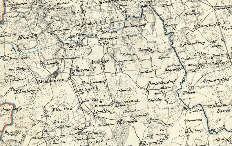
| Description / Beschreibung |
Ausschnitt Mühlhausen (Pr.Hollannd) aus der Reymanns Spezialkarte Nr.19 Heilsberg |
|---|---|
| Source / Quelle | |
| Scans / Scans | |
| Date / Datum |
um 1800 |
| Author / Urheber |
Reymann |
| Remarks / Anmerkungen |
Reymanns Spezialkarte Nr.19 Heilsberg |
| Permission / Genehmigung |
|
Lizenz
| The author of this image (scan or other media file) declares it public domain. The copyright of its original source (photography, book,...) has expired. This applies to the United States, Canada, the European Union and those countries with a copyright term of life of the author plus 70 years. |
Dateiversionen
Klicke auf einen Zeitpunkt, um diese Version zu laden.
| Version vom | Vorschaubild | Maße | Benutzer | Kommentar | |
|---|---|---|---|---|---|
| aktuell | 19:46, 20. Jan. 2014 | | 2.174 × 1.367 (2,14 MB) | Geraldraq (Diskussion • Beiträge) | ==Beschreibung== {{Information |Beschreibung =Ausschnitt Mühlhausen (Pr.Hollannd) aus der Reymanns Spezialkarte Nr.19 Heilsberg |Quelle = http://igrek.amzp.pl/1760803 |Urheber = Reymann |Datum = um 1800 |Scans =http://www.mapywig.org/m/German_maps/series |
Du kannst diese Datei nicht überschreiben.
Dateiverwendung
Die folgenden 42 Seiten verwenden diese Datei:
- Baarden
- Borchertsdorf (Landkreis Preußisch Holland)
- Breunken
- Deutschendorf (Landkreis Preußisch Holland)
- Ebersbach (Landkreis Preußisch Holland)
- Falkhorst
- Fürstenau (Landkreis Preußisch Holland)
- Guhrenwalde
- Gut Erlau
- Gut Kagenau
- Gut Lipprode
- Gut Nikolaiken
- Hermannswalde (Landkreis Preußisch Holland)
- Herrndorf (Landkreis Preußisch Holland)
- Jonikam
- Karwinden (Landkreis Preußisch Holland)
- Klein Quittainen
- Lauck (Landkreis Preußisch Holland)
- Lohberg (Landkreis Preußisch Holland)
- Louisenwalde (Landkreis Preußisch Holland)
- Monbrunsdorf
- Mühlhausen (Landkreis Preußisch Holland)
- Mühlhausen (Landkreis Preußisch Holland)/Reymann Karte 12
- Neu Münsterberg (Landkreis Preußisch Holland)
- Neumark ( Landkreis Preußisch Holland)
- Schlobitten (Landkreis Preußisch Holland)
- Schlodien
- Schönaich (Landkreis Preußisch Holland)
- Schönberg (Landkreis Preußisch Holland)
- Schönfeld bei Mühlhausen
- Schönfließ (Landkreis Preußisch Holland)
- Seepothen (Landkreis Preußisch Holland)
- Spanden
- Suche (Landkreis Preußisch Holland)
- Sumpf (Landkreis Preußisch Holland)
- Vaterswille (Landkreis Preußisch Holland)
- Vorwerk Erlau
- Vorwerk Fürstenwille
- Vorwerk Hensels
- Vorwerk Muttersegen
- Vorwerk Schlobitten
- Vorwerk Spitzen